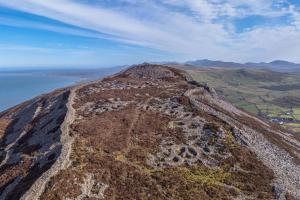
Ynys Enlli (Bardsey) viewed from Mynydd Mawr, Penllŷn

LIVE (Llŷn Eco-museum)

LIVE is a collaboration between Welsh and Irish community organisations, academic departments and local governments. LIVE aims to enable coastal communities to promote their natural and cultural assets, creating opportunities for sustainable tourism, especially outside of the traditional peak tourist seasons.

Bangor University’s Sustainability Lab worked with the Welsh partners to co-develop the #Ecoamgueddfa, the first ecomuseum in Wales and, to our knowledge, the first digitally-driven ecomuseum in the world. The team is now based in the School of History, Law and Social Sciences, and they are working closely with the School’s archaeologists in order to deliver a range of community-engagement events and archaeological digital resources. The latter includes 360-degree virtual tours which showcase the spectacular archaeological heritage that Pen Llŷn has to offer. 

You can explore the virtual tour of the Iron Age and Romano-British hill fort of Tre’r Ceiri here. The imagery and virtual tour was created by Bernd Kronmueller, Panoramas and Virtual Tours. 

Tre’r Ceiri

The spectacular Iron Age and Romano-British hillfort of Tre’r Ceiri sits on the eastern-most hilltop of Yr Eifl, Llanaelhaearn on the Llŷn Peninsula. It is one of the best-preserved hillforts in Britain and a protected ancient monument. Hillforts were gathering sites: they were places for settlement, food storage, and ceremony, and they provided a central focus for communities who lived within these landscapes during the first millennium BC and the first half of the first millennium AD. The hillfort is enclosed by an impressive stone wall, with two main entrance-passages, and up to 150 roundhouses and rectangular structures are located inside. The inhabitants of the hillfort respected an earlier Bronze Age burial cairn, which sits on the hill summit. 

Immerse yourself in a virtual tour of this monument and its surrounds. Text and audio can be changed to Cymraeg or English by clicking on the flag icons. 

  • Ecoamgueddfa and LIVE Project – www.ecoamgueddfa.org |  www.ecomuseumslive.eu
  • Imagery and virtual tour created by Bernd Kronmueller, Panoramas and Virtual Tours 
  • Tour text summaries created by Dr Kate Waddington
  • Bangor University Film by Cai Erith, Forrest Lancaster and Rhys Mwyn

Imagery and virtual tour created by Bernd Kronmueller, Panoramas and Virtual Tours

Accessible Description of the 360 Experience

Tre’r Ceiri is situated on the eastern hilltop of the three peaks of Yr Eifl and it is the highest Iron Age hillfort in northwest Wales and arguably the best preserved hillfort in Britain. Hillforts are gathering sites: they were places for settlement, food storage, assembly and ceremony; they provided a central focus for communities who lived within these landscapes and who farmed the lower lands; and they were a place of refuge during times of crisis. This densely occupied hilltop settlement dates to the Iron Age (600BC–AD 79) and Romano-British period (AD 79-410), and it may also have been (re)occupied in the early medieval period as well (AD 410-1050). The site has been the focus of a number of excavations, including those in the early twentieth century by Hughes, Baring-Gould and Burnard, as well as in the 1950s by A.J. Hogg. These excavations explored the site and its buildings in detail and they have provided a good deal of information regarding the layout of the site and the various finds recovered from the buildings. More recently, Hopewell and Boyle from Gwynedd Archaeological Trust have carried out consolidation work to clear and reconstruct some of the entrance-ways, ramparts and roundhouses. Smith investigated the earlier Bronze Age burial cairn which sits on the summit. 

Our understanding of the precise dating of the hillfort and its various construction and occupation phases remains limited as no radiocarbon dates exist. However, it is possible to make interpretations on the dating of different occupation phases based on the recovery of dateable artefacts from the hillfort’s c. 150 buildings. The simple roundhouses are Iron Age, but the later small irregular cells, partitioned roundhouses and rectangular buildings are Romano-British, and it is possible that some of the larger rectangular huts may well have been built in the early medieval period. 

Tre'r Ceiri’s elevated position and monumental architecture reveals that this was a place of power, assembly, settlement, refuge and ritual for millennia. It can be experienced today by way of the mountain and coastal footpaths located on the scenic Llŷn peninsula.

Tre’r Ceiri hillfort is enclosed by a monumental stone-faced wall, preserved up to 3m wide and 3.5m high, with two main entrance-passages positioned on the south-western and north-western sides. The rampart wall is spectacularly well preserved and original parapet breastwork (wall-walk) can be seen to run along the top of the rampart in some sections. This would have enhanced the visual and defensive impact of the boundary and it would also have enabled the occupants of the hillfort to position themselves on the top of the wall. Other parts of the rampart incorporate massive stone outcrops running along the edge of the hilltop plateau, visible on the southern and eastern sides. 

At a later date, an outer wall was built on the western side of the hill, providing additional space for the occupants. Recent consolidation work of the ramparts and entrance-ways by David Hopewell of Gwynedd Archaeological Trust has been important in developing our understanding of the site: a number of areas have been cleared and stabilised in a conservation effort and this has made the spectacular archaeology easier to understand and see. 

The hillfort has two main entrance-ways positioned in the south-western and north-western end of the hillfort, which are both around 2m wide. Three additional small, narrow entranceways are located in the ramparts on the east, west and northern sides – some of these may have provided access to the hilltop’s springs. The two main entrance-ways in the southwest and west are approached by sunken track-ways with flanking walls. The south-western entrance-way appears to have been one of two main approaches to the hillfort: this was approached by a sunken trackway which winds through a series of over twenty small, stone-walled field enclosures which are located just outside this entrance-passage and which may have been constructed after the creation of the outer rampart. The approach to this entrance is very steep. The north-western entrance was probably the main entrance: this consists of a long and narrow passage-way flanked by high walls which is impressive and well-defended.

All of these entrances had become blocked with stone rubble. Some of them were cleared and partially rebuilt during the consolidation and conservation work of David Hopewell and a team of local dry-stone wallers in the 1990s. Clearance and excavation in the north-western entrance-passage (c. 2.5m wide) revealed that this had been remodelled and rebuilt in the Romano-British period and a Roman jar was found here. This demonstrates the extent to which the original Iron Age ramparts and entrance-ways were refashioned during the occupation of the settlement in the first millennium AD.

David Hopewell’s recent analysis of the site has revealed that the enclosure contains over 11 stone roundhouses, 11 rectangular buildings, and 123 irregular huts (some produced by subdividing roundhouses), many of which are in clusters and conjoining. The roundhouses have entrances facing in a variety of directions. 

The first roundhouses built on the site were large simple roundhouses and these date to the Iron Age period. In a later period, many of the roundhouses were subdivided and smaller irregular cells and rectangular buildings were added to pre-existing buildings. Fifteen of the Iron Age round houses were remodelled in a later period into pairs of sub-rectangular buildings by the addition of a partition wall and other masonry. Many of the subdivided roundhouses (62%) produced Romano-British pottery, whilst very little pottery of this date was recovered from the simple Iron Age roundhouses (only 11% produced Roman pottery). This reveals that much of the later building work took place in the Romano-British period. This practice of building over many centuries has led to the clusters of interconnected houses and buildings that we see on the site today.

Finds from excavations include Iron Age spindlewhorls, a saddle quern, stone tools, as well as elaborate blue-glass beads and metalwork, including a later Iron Age bronze beaded armlet or torc from hut 41. A range of Romano-British dateable objects reveal the importance of this settlement in the first few centuries of the first millennium AD – the finds include Roman pottery, stone tools, and personal ornaments, including a spectacular gold-plated bronze bow-brooch (from hut 10; National Museum Wales collection). The recovery of an antler/bone comb with concentric-dot decoration from hut 23 is interesting – this artefact might be Romano-British but equally it could date to the early medieval period.

A large earlier Bronze Age burial cairn occupies the summit of the hilltop at the north-eastern end of the enclosure. This consists of a large mound of stones which provided a burial place for the dead. The burial cairn at Tre’r Ceiri was recently explored and consolidated by George Smith of Gwynedd Archaeological Trust. He identified the foundations of a wall of outer kerb stones around the base of the mound and a fragment of cremated bone. 

Round barrows or cairns are a common feature of the Early and Middle Bronze Age landscapes in Britain (c. 2500-1500/1200 BC)and they usually contain multiple cremation burials which were interred over time. They provided focal places in the landscapes where groups would gather for funerals and other ceremonies, and they marked the location of important places. Hilltop burial cairns like these are found throughout the Llŷn peninsula and North Wales (if you would like to visit an alignment of earlier Bronze Age hilltop burial cairns, you might be interested in LIVE’s Archaeological walk on Mynydd Rhiw), and they reveal the conceptual importance of hilltops within earlier Bronze Age society. A number of hilltop cairns are found within Iron Age hillforts, and it is significant that the occupants respected the ancient monuments rather than robbing the stone for buildings, as is visible at Tre’r Ceiri. It is possible that the Iron Age hillfort occupants were justifying their rights to that land by claiming that their ancestors were buried within the ancient burial monument.

We will shortly also be able to offer two additional virtual tours – one of the manganese mines at Nant, Porth Ysgo, and another of the granite quarries at Trefor (the latter is adjacent to Tre’r Ceiri hillfort). All three tours also offer panoramic views of the stunning coastline at these locations.

multiple Logos

It looks like you’re visiting from outside the UK, would you like to be redirected to the international page?